| Lawson Hill Farm Weather Data | |||
|---|---|---|---|
| LAST READING AT TIME: 5:25 PM DATE: June 14 2026, time of next update: 5:30 pm | |||
| Current Weather | Night time/Dry | Current Temperature | 69.8°F (21.0°C) (Heat Index 69.8°F ), Apparent temp 72.0°F |
| Maximum Temperature (since midnight) | 80.0°F at: 1:40 PM | Minimum Temperature (since midnight) | 66.4°F at: 3:16 PM |
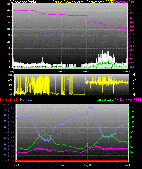
| Average windspeed (ten minute) | 4.1 mph | Wind Direction (ten minute) | NNW (339°) |
| Heat Index | 69.8°F | Maximum Gust (last hour) | 15 mph at: 5:18 PM |
| Maximum Gust (since midnight) | 16 mph at: 2:37 PM | Maximum 1 minute average (since midnight) | 10.5 mph at: 12:48 PM |
| Rainfall (last hour) | 0.00 in. (0.0 mm) | Rainfall (since midnight) | 0.16 in. (4.1 mm) at 2:27 PM |
| Rainfall This month | 2.26 in. (57.4 mm) | Rainfall To date this year | 31.02 in. (787.8 mm) |
| Maximum rain per minute (last hour) | 0.00 in/min | Maximum rain per hour (last 6 hours) | 0.15 in/hour |
| Yesterdays rainfall | 0.00 in | DewPoint | 62.6°F (Wet Bulb :65.4°F ) |
| Humidity | 78 %, Humidex 79.3°F | Barometer corrected to msl | 29.844 in. (1010.6 hPa) |
| Pressure change | +0.02 in. (last hour) | Trend (last hour) | RISING SLOWLY |
| Pressure change (last 12 hours) | +0.04 in | Pressure change (last 6 hours) | +0.05 in |